Friday, 16 March 2018

Kelowna to Phoenix by way of Las Vegas

The day has arrived!  After getting the boys from school we hitch up the trailer, say good-bye to Dominic, who opted to stay home with his Dad this trip, and hit the Happy Highway. 


Kelowna, BC --> Omak, WA.

We hope to leave all of the cold weather and snow behind!

We are happily situated at Walmart with fellow overnight RV's. Hmm, I think we parked too close to that very bright lamp standard before!


Rise and shine. Today we will drive from Omak, WA over Deadman's Pass to Farewell Bend State Recreation area. Note how close we are to the city of Ontario. This is important later. 

This is love - holding your sons' pants by the heater so that they warm up a bit before he gets out of bed. 

It is a crisp new day with some low lying fog in the Okanogan Valley in north/central Washington. 

As we gain elevation we find more mist and fog but nothing too serious. The roads are very lightly travelled and we are making good time. 

This is some point near Soap Lake. We have turned south and travel through the mini-Grand Canyon of Washington State. Each time we pass I think, 'We really need to camp at Sun Lakes Dry Falls State Park!'


Othello, WA. This makes an excellent stopping point. This Walmart had massive, fresh turkey sub sandwiches for less than $6.00  This is one third of the sub. And, there is a nearby gas station that is cheaper than the one on the highway. This stop is only 0.5 mile off Highway 17 on W. Cunningham Road. 


In the past we have driven I-82 over the bridge at Plymouth and Umatilla so it was unusal not to travel through Kennewick. Google Maps took us on Route 12 to Route 730 which was easy and very beautiful. 

We drove along the Columbia River where the telephone poles still boast many glass insulators. 

This route takes you through very small, rural roads so weren't we surprised to see a small herd of Buffalo!   
These roads reminded me of driving through farms in Abbotsford. I was starting to doubt Google Maps but we hooked up nicely with I-84 in Echo, OR.


After Pendleton, OR the interstate rises up and crosses Dead Man's Pass. This section is worthy of note as it can be hammered by late winter storms.  Use Oregon's Tripcheck website for current driving conditions and highway cams. 

We planned a stop in Baker City, before 4:30 pm, to purchase an American The Beautiful national parks pass. This ended up being about 10 minutes off the highway so it was a bit of a journey; however, we will make great use of this pass so it was worth it. 


Farewell Bend State Park. This large park has one loop open in winter next to the river. You do have to drive through al ot of 'park' before you get to that loop; however, it is well-signed.  I was somewhat apprehensive until we rounded the final bend to see 3-4 other RV's already in place. This park is only 5-7 minutes off the highway. Far enough away to damped the highway sounds significantly.  Each site has power and water; however, the water to the camp had not yet been turned on due to the cold conditions. Long sites meant we did not have to unhitch. Rain was forecast for the early morning but no freezing so things are looking good.  A snow storm is forecast for Ely, NV late the next evening so we hope to make a very early start to get over the pass at Ely before dinner time to avoid being stuck in Ely an extra night.  

Our site had a nice path down to the river. 

Alex is in his happy-place watching Corner Gas and playing old Pokemon games on his DS which he hasn't played in years.

Day 3 on the road:  We did not plan to drive this far; however, by the time we got to the next camping place past Ely - we only had 1 hour 45 minutes to Vegas. So, why not?!


The rain woke me up at about 5 am. So, I got on my wet weather gear, cranked up the corners, stowed the electric cord and woke up Alex. We were on the road in the dark. this is me trying to find the money box to pay for our camping. Because we ended up driving so far into the park I never did walk the mile back to the entrance that evening. No problem we will pop our money in the box on the way out.  Turns out this was not the 'box'. This was the day use area. We never did find the box in the sleet and dark. We apologize Oregon State Parks and appreciate your hospitality. 


Remember the earlier map where I said, 'See how close we are to Ontario, OR?'  We were close; however, big 'however', that short distance also comes with an elevation gain. This gain was enough to turn the pesky rain into a huge Canadian cotton-ball white out. We are towing a travel trailer  in the dark, on a mountain highway, in a white out, on now compact snow. It wasn't good. I geared down, put the flashers on, moved to the middle of the highway as the edges were difficult to see and we crawled along for about 5 kilometres until we saw a very welcome exit sign.  We pulled up to two other semi-trailers taking refuge there. It ended up that we only needed to stay for about 20 minutes before dark became light. Soon we were off again. I knew that at that point we were only about 5-7 kms from Ontario; however, stopping was wise. Despite all of my weather planning - unexpected things still occur. Don't tell Dad!!!


Oh happy day. We are out of the snow and at the travel plaza in Ontario, OR.  Check out the snow on the trailer and running boards.  My goodness. 


This about sums up travelling east from Oregon into Idaho.......


At Twin Falls, we get to turn south. Just before you cross the Snake River Bridge there is a very trailer friendly (if it is not too busy) pull out on the right. If the linearly lot is full you can easily get out again and just carry-on across the bridge. There is a lovely view just 30 meters down a gently slopping trail. 

Alex constructs some turkey coleslaw wraps for our lunch. 


Snake River Bridge, Twin Falls, Idaho. Three years ago I was still taller than Alex. 

An easy place to pull out that is divided from this highway by a concrete barrier (not seen). 


Google Maps even tells you the price of gas and where to find it.


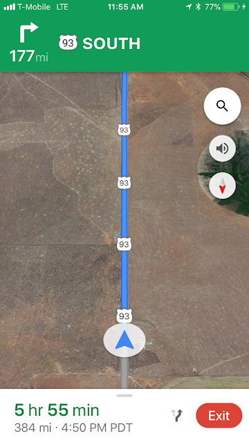
Yes, no turn for 177 miles. For real.


We begin our journey through the Never Ending Valley. 


I think this is south of Wells, NV. I do not recall snow on these mountains last time.


The weather threatened but never broke.


This was the forecast for Ely, NV which was supposed to be our stopping point. Leaving Ely the highway rises and twists for about 30 minutes. Not a good place to be with a trailer in the snow. We knew this which is why we made such an early start. 

Leaving Ely, NV.  No snow and the roads are clear and dry. Perfect. 

The ascent is followed by a narrow, curvy descent. Traffic is light so we can gear down and take our time here.

2 hours south of Ely is Ash Creek and Alamo. Both have some reasonable overnight parking places. We gas up in Ash Creek and call ahead to Las Vegas - can we come a day early?  No problem. So, onward we go as we are under 2 hours away. We are treated to a delightful sunset. 


About an hour before we arrive the sun sets and we enter Las Vegas on a Friday night. Time to up my game as we listen to Google direct us through a few highway interchanges. This feels like Los Angeles except here no one knows were they are going. Thankfully, we get through about 25 minutes of Las Vegas highway pinball and arrive in one piece just after 8 pm. Phew, it has been 14 hours since the white-out - did that happen? It is all a blur. 


The Oasis RV Resort boasts over 900 spots, for real. They have everything worked out to a fine art. Staff were very pleasant and welcoming. They even have 6 fancy palm tree lined check-in lanes (above) all lit up and fancy. We are in our spot and tucked into bed in record time. Tomorrow is another day.

No comments:

Post a Comment